 Memorial & Picnic Table at Verona Park'n Ride
Fitchburg Quarry Ridge Recreation Area: 2740 Fitchrona Rd, Fitchburg - Restrooms and parking.
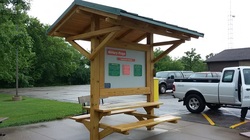
Verona: 2565 Old Co Rd PB, Verona - Parking is available at the trailhead at County Highway PB, just off of State Highway 151. There is also self-registration and an informational kiosk.
306 S Main St, Verona - Parking and trail access are also available at Quarry Ridge Recreation Area along with restrooms and picnic shelters. Follow County Highway PD west from US 18/151; turn left on Nesbitt Road then left on Fitchrona Road. The park is about 0.3 mile on the left. There is a paved path to the Military Ridge Trail.
Riley: 3087 Co Rd J, Verona - A parking lot is next to the trail off County J near the intersection of County J and Klevenville Riley Road. Also self-registration, informational kiosk and a portable toilet are available.
Mount Horeb: 116 S Second St, Mt. Horeb - Parking is adjacent to the trail comfort station located on the first block of South Second Street. The comfort station has bathrooms, a drinking fountain, self-registration, and an informational kiosk.
Blue Mounds: 4350 Mounds Park Road, Blue Mounds - Parking is available in a lot next to the trail. Take Highway ID to Mounds Park Road, turn north. The lot is adjacent to the Mound View Village Park. Blue Mound State Park has bathroom facilities, camping, and self-reg.
Barneveld: Near Church St, Barneveld- Kiosk and parking lot are available here.
Ridgeway: 618 Main St, Ridgeway - Parking is available near the restored railroad depot on Main Street in downtown Ridgeway near the water tower. An informational kiosk is there. Bathrooms and a museum are in the Depot which is open in the summer, 1st Sundays from 1-3. The caboose can also be toured when the Depot is open.
Dodgeville: 322 N Douglas St, Dodgeville - Parking, restrooms, self-registration, and kiosk are at the N Douglas St address.
Parking is available at the western end of the trail in Dodgeville at the DNR center at 1500 N Johns St and about 0.25 miles east of Highway 23 on County Highway YZ.
Parking is available at the western end of the trail in Dodgeville at the DNR center at 1500 N Johns St and about 0.25 miles east of Highway 23 on County Highway YZ.
