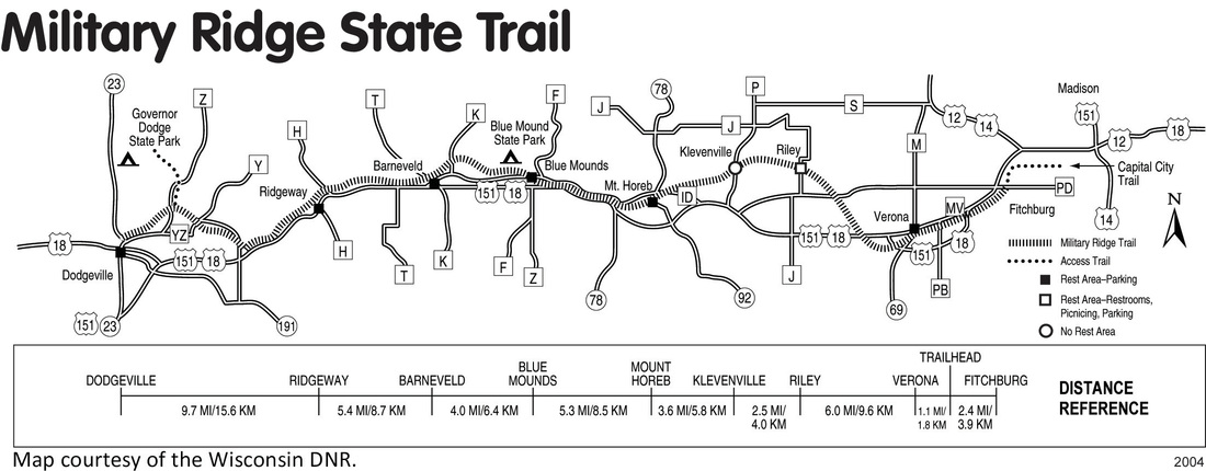
Friends of Military Ridge Trail
  • Home
  • About Us
  • Better Alternatives
  • Join Us
  • The Trail
    • Trail Descriptions
    • Parking and Facilities
    • Trail Passes
    • Trail Map
    • Brochure to download
  • Events
    • Other Events
  • Photo Gallery
  • History
    • History of Trail
    • History of Communities >
      • Dodgeville and Ridgeway
      • Barneveld and Blue Mounds
      • Mt. Horeb and Klevenville
      • Riley and Verona
      • Fitchburg and Madison
  • Contact Us

FRIENDS OF MILITARY RIDGE TRAIL

Picture
Note that this map does not show the following three access trails:

Brigham County Park and Cave of the Mounds - Just west of the tunnel under County Highway ID a 1.3 mile spur provides access to both Cave of the Mounds (.1 miles from the trail) and Brigham County Park (1.2 miles from the trail). This access trail is quite steep in spots.

Blue Mounds State Park -Approximately 0.7 miles west of Mounds Park Road a trail spur heads north and provides access to Blue Mounds State Park. This trail is quite steep in spots.

Governor Dodge State Park- A steep access road leads to Governor Dodge State Park from County Road Z. To get to this access road leave the trail where it intersects with County Road Z and travel a short distance north on County Road Z.
Website by Tamlyn Akins Art & Design
  • Home
  • About Us
  • Better Alternatives
  • Join Us
  • The Trail
    • Trail Descriptions
    • Parking and Facilities
    • Trail Passes
    • Trail Map
    • Brochure to download
  • Events
    • Other Events
  • Photo Gallery
  • History
    • History of Trail
    • History of Communities >
      • Dodgeville and Ridgeway
      • Barneveld and Blue Mounds
      • Mt. Horeb and Klevenville
      • Riley and Verona
      • Fitchburg and Madison
  • Contact Us